To provide an accurate risk assessment, underwriters and insurance companies need accurate geospatial data for specific locations.
Incorrect addressing data can lead to incorrect insurane policies and costly delays, meaning incorrect fees, unhappy customers and lost profits.
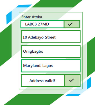

The most complete addresses information with options to include enhanced datasets such as 'Just Built', 'Not Yet Built', 'Multi Residence' and 'Location Intelligence', helping you to understand the full picture of the data you capture.

The most up to date data delivered seamlessly in the background so your service is never interrupted.

You can collect accurate data about your customer no matter what device they use.
1Lorem Ipsum is simply dummy text of the printing and typesetting industry. Lorem Ipsum has been the industry's standard dummy text ever since the 1500s, when an unknown printer took a galley of type and scrambled it to make a type specimen book. It has survived not only five centuries, but...
Catherine, Founder
Lorem Ipsum is simply dummy text of the printing and typesetting industry. Lorem Ipsum has been the industry's standard dummy text ever since the 1500s, when an unknown printer took a galley of type and scrambled it to make a type specimen book. It has survived not only five centuries, but...
Catherine, Founder


Lorem Ipsum is simply dummy text of the printing and typesetting industry.
Read out more
Lorem Ipsum is simply dummy text of the printing and typesetting industry.
Read out more
Lorem Ipsum is simply dummy text of the printing and typesetting industry.
Read out moreWe are ATOKA - Nigeria's most trusted address data specialist, providing location intelligence for business of all sectors and sizes. We combine the best global technologies and capabilities to offer the Nigerian solution to meet local needs.
Edinburgh, Scotland, EH4 4TF


 International